Six Taipei Trails That Look Like Parks but Aren't
Six easy urban trails within Taipei city limits — most reachable by MRT, all doable in an afternoon. Each one looks like an ordinary green hill. Under the surface: an abandoned Qing-dynasty coal mine a 15-minute walk from Taipei 101, a Da'an District forest accidentally preserved by 50 years of military lockdown, a 6,000-year archaeological site that doubles as a morning dog-walking park, and a trail where planes from Songshan Airport sweep directly overhead every 15 minutes.
When Taipei locals say they're "going hiking," they usually mean something closer to "catching the MRT, walking 15 minutes to a trailhead, and being home before dinner." These aren't serious mountain climbs — they're walks with inclines.
All six trails here fit that description. They're inside Taipei city limits, most are MRT-accessible, and none takes more than two hours round-trip. They also all look, at first glance, like unremarkable city parks. Each one has a reason to look twice.
Hushan Creek Trail (虎山溪步道) — and the abandoned coal mine next to Taipei 101
Xinyi District · 10–15 min walk from MRT Xiangshan Station · Loop ~1.5–2 hrs
Most people who come to this area head up Elephant Mountain (象山, Xiangshan) on the east side — the one with the straight-on view of Taipei 101. Tiger Mountain (虎山, Hushan) is the next hill north. No famous viewpoint, fewer people.
The creek trail runs along a valley with half-shade, dense ferns, and a few stone arch bridges crossing the stream. In April and May, fireflies come out in the evenings — yellow-edged fireflies and black-winged fireflies both — and locals from Xinyi District treat it as a seasonal ritual.
At the summit platform, the Xinyi skyline opens up in front of you. Taipei 101, Nanshan Plaza, the high-rise cluster — Hushan is low enough that you're looking at the skyline at eye level rather than down at it. It feels less like an overlook and more like standing at the city's edge.
A few minutes' walk from the summit, past Yaochi Temple (瑤池宮), there's an old coal mine entrance. Records of mining here go back to the Qing Dynasty's Guangxu era; formal extraction started in 1923 under the Japanese colonial administration. At peak operation, over 500 workers were employed. The coal brand was called "Songshan Carbon" (松山碳) and was well-known across Taiwan. Mining stopped in 1991. The tunnel entrance is right by the trail — there's a small explanatory sign that's easy to walk past.
- Trailhead: MRT Xiangshan Station, walk toward Songren Road. Search "虎山登山口" on Google Maps.
- Time: Full loop including summit ~1.5–2 hrs
- Open: 24 hours
Fuyang Eco Park (富陽自然生態公園) — the Da'an forest that exists because of a military lockdown
Da'an District · 5 min walk from MRT Linguang Station · Loop ~40–60 min
Da'an is one of Taipei's most densely developed districts. The reason this particular patch of land on Fuyang Street never became apartment blocks is simple: the military locked it down for roughly 50 years.
The area was a military installation in the late Japanese colonial period. After 1945, the ROC military took it over as an ammunition depot. The munitions were removed in 1988, and the park officially opened in 2006.
The side effect of all that restricted access: the secondary forest here was never cleared. While the surrounding Da'an District was being built up, these trees were left alone for decades. The canopy is high, the shade is dense, and in summer the temperature drops noticeably as soon as you walk in.
Along the trails you can still see the military infrastructure: seven or eight bunkers, tunnel entrances, guard posts, military boundary markers, and stone steps with characters carved into them by the soldiers who were stationed here. None of this is staged — it's just there, some of it without any signage.
- Address: Fuyang Street, Da'an District (5 min walk from MRT Linguang Station)
- Time: Loop ~40–60 min
- Open: 24 hours, free entry
Zhishanyan (芝山岩) — six thousand years of archaeology disguised as a morning walk
Shilin District · 15 min walk from MRT Zhishan Station · Loop ~1–1.5 hrs
Zhishanyan looks like a standard Taipei hillside park: 51 meters, 10 hectares, morning tai chi practitioners, dog walkers, a temple at the top. Walk in and you notice it's a little different — the camphor trees are old enough that some take two or three people to reach around, and there are a few large sandstone boulders along the path, known locally as the "Four Heavenly Kings," that you don't see on most Taipei trails.
Below ground is one of the most significant archaeological sites in Taiwan. Over 6,000 years, this land accumulated seven distinct cultural strata. The lowest layer: shell middens left by people who ate seafood here 6,000 years ago, still compressed under the soil. In the middle is a layer called "Zhishanyan Culture" — named after this specific site because that's where it was first identified. The top layer is Qing-era Han Chinese: the evidence of civil conflicts between Zhangzhou and Quanzhou settler groups, the stone tablets, and the temples that are still here today. Taiwan's first formally documented prehistoric site was Zhishanyan, in 1896. Nowhere else in Taiwan has seven distinct periods stacked in one place.
Other remnants from different eras are scattered around the hill. A stone tablet recording the Zhangzhou-Quanzhou conflict stands in the memorial garden. The 120 stone steps of the Baier Kan Trail (百二崁步道) were built as an approach path to the Shinto shrine here during Japanese rule — the shrine is gone, the steps remain, and they're now what the neighborhood uses to walk up the hill every morning.
- Address: Near Fuguo Road, Shilin District (15 min walk from MRT Zhishan Station, or take a bus to "Zhishanyan Stop")
- Time: Loop ~1–1.5 hrs
- Open: 24 hours
Tianmu Ancient Trail (天母古道) — the steps the American military didn't build
Tianmu, Shilin District · No direct MRT · One way ~1.5–2 hrs
Tianmu is closely associated in Taiwanese memory with the American military presence. From the 1950s through the 1970s, US military advisors and their families were stationed here, and the neighborhood absorbed the influence — international schools, steak restaurants, a Western-inflected atmosphere that lingers to this day along Zhongshan North Road Section 7.
The Tianmu Ancient Trail (天母古道), also called the Water Pipe Trail, feels deliberately constructed. The stone steps are even, the route is clear, and it's natural to assume the Americans built it for access between their hillside facilities and the residential area below.
The steps were laid in 1932. The Americans arrived nearly two decades later.
The trail's original purpose was maintenance access for the Caoshan Water System (草山水道系統), a Japanese colonial-era infrastructure project that brought water down from Yangmingshan. The steps were built so that workers could inspect and repair the pipes — the people who walked this path were engineers, not hikers.
The black water pipe is still visible along the trail today, running against the hillside and half-merged with the vegetation. The path is well-shaded, there's a stream audible nearby, and in summer it stays cooler than most Yangmingshan trails. About 1,300 stone steps from the Tianmu commercial area up to near Chinese Culture University.
- Trailhead: Near Tianmu commercial area. Search "天母古道登山口" on Google Maps (multiple entry points).
- Time: One way ~1.5–2 hrs
- Transit: No direct MRT. Take a bus to the Tianmu area.
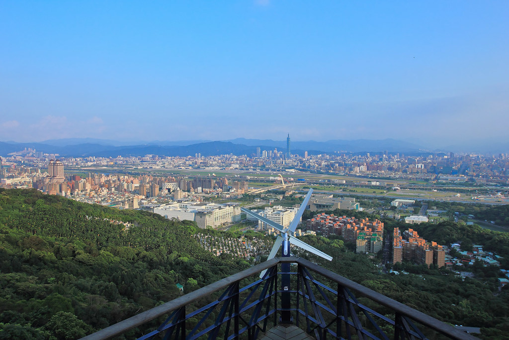
Lao Di Fang Viewpoint, Jiantan Mountain (劍潭山老地方觀機平台) — abandoned guard posts and low-flying planes
Shilin District · 10 min walk from MRT Jiantan Station · Round trip ~2 hrs
The trail starts in dense forest, canopy overhead, views closed in. Occasionally an abandoned military guard post appears on the side of the path — no signage, nothing explaining it, just there. Then the trail reaches Lao Di Fang (老地方, literally "the old place"), and the view opens completely.
From the platform: Songshan Airport's runway, the bend of the Keelung River, Taipei 101, Guanyin Mountain in the distance. The unusual thing is Songshan Airport. It's a domestic and cross-strait airport that sits inside Taipei proper, and the viewing angle from here is very close. This isn't a plane as a distant speck. You hear the engine, then the aircraft sweeps directly across your field of vision. Flights run every 15 to 20 minutes; on a busy stretch, you can stand on the platform for a long time.
Two newer viewpoints were added in 2023 — the Breeze Platform (微風觀景平台) and the North Eye Platform (北眼平台, a white sphere structure) — reachable in about 30 minutes. They have views but are smaller than Lao Di Fang, which is the 60-minute mark.
- Trailhead: 10 min walk from MRT Jiantan Station. Search "劍潭山老地方觀機平台" on Google Maps.
- Time: Round trip ~2 hrs (one way to platform ~60 min)
- Open: 24 hours
Xianjiyan (景美仙跡岩) — 144 meters, and Taipei 101 is still taller than where you're standing
Wenshan District · 10 min walk from MRT Jingmei Station · Summit 15 min, loop ~1 hr
Xianjiyan (景美仙跡岩, also called Jingmei Mountain) is a neighborhood trail in Wenshan District — the kind of place where the same retired couples pass each other on the path every morning. It's 144 meters. From the main entrance (beside the archway at No. 241 Jingxing Street), it's 15 minutes to the top.
In April and May, tung blossoms fall along the stone steps — white petals against dark stone, the standard spring image in this part of Wenshan.
At the summit there's a large rock with a clear depression in it. The temple caretakers say it's the footprint of Lü Dongbin (呂洞賓), one of the Eight Immortals of Chinese Taoist mythology. The legend comes in two versions: one says Lü Dongbin, pursuing the immortal He Xiangu, was pushed down to earth and landed first on Toad Mountain near Gongguan, decided he didn't like the location, took one step, and landed here at Jingmei. The other says it was Liu Hai, another immortal, who left the mark after subduing a toad demon. Both versions agree: there's a divine footprint on the rock.
The view at the top is an odd one. Standing at 144 meters, Taipei 101 is still higher than you are. It doesn't feel like looking down at the city — it feels like being surrounded by it, with a small bump of hill under your feet.
The trail has 14 separate entrance points. If you're staying in Wenshan District, you can likely find one close to your accommodation.
- Main entrance: No. 241 Jingxing Street, Wenshan District (10 min walk from MRT Jingmei Station)
- Time: Summit 15 min, full loop ~1 hr
- Open: 24 hours
Sources
- Hiking Taiwan — Fuyang Eco Park Trail
- Taipei City Government Parks Department — Fuyang Eco Park
- Taiwan History at Zhishanyan (vocus)
- Hiking Taiwan — Zhishanyan Trail System
- Tiger Mountain, Songshan Coal Mine No.1, Hexing Coal Mine (Tony Huang's Natural & Cultural Journal)
- Songshan Mining History (National Cultural Memory Database)
- Xianjiyan Trail, Wenshan District (vocus)
- Jingmei Neighborhood Half-Day Walk (Smile Taiwan)